
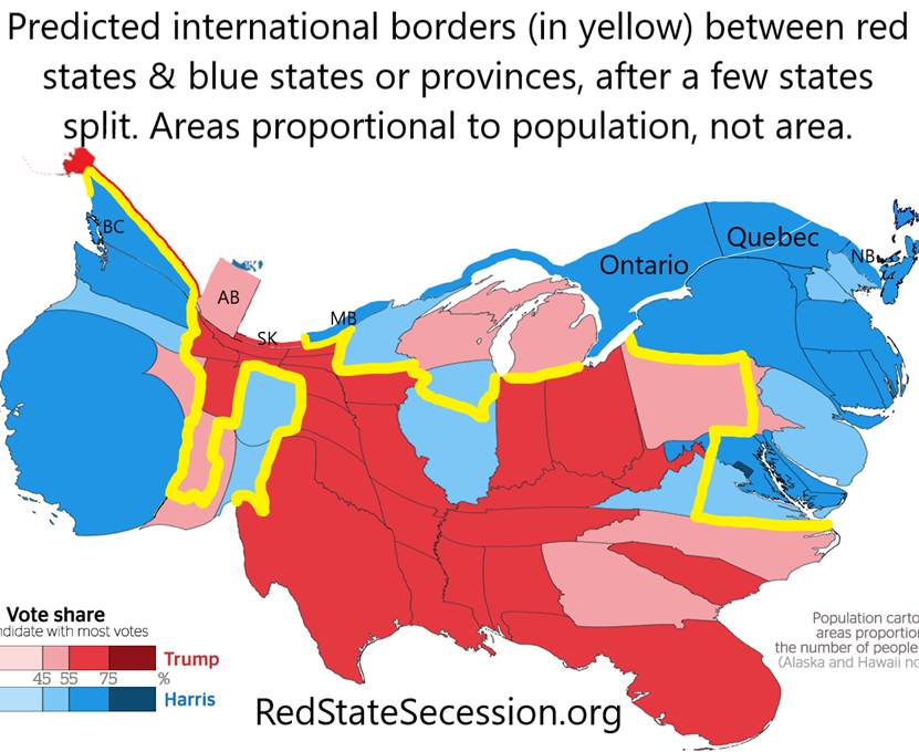
Saskatchewan and Alberta would be good additions to the US and to a federation of red states. Saskatchewan’s per capita personal income is 3% higher than the red-state ave, and Alberta 20%.
The populations of Yukon, NW Territories, and Nunavut are less than 41k each, so they are just as good a deal as Greenland. Perhaps they can be bought off to join as territories just like Greenland, to get access to mining & fishing. Same with the N edge, NE corner, and SE corner of British Columbia, to get the highways. The corners lean GOP. Maybe any blue areas of Alaska’s panhandle could be traded for these areas.

“Irish Patriot” on X found that Saskatchewan is a true red state, and Alberta is a purple state (9% advantage for the GOP). At D+20, Manitoba is a true blue state, like the rest of Canada and Minnesota, which it borders.

He calculated the strength of Canadian support for the GOP by taking 85% of the Conservative vote percentage plus all of the PPC vote % in the 2021 federal election. That’s a bit generous since their “Conservative Party” supports socialist medicine and was pro-immigration until the whole country realized there were no houses left.
But secession would make both provinces redder. Canada has a higher % of recent immigrants than the US, so it would be easier to deport enough left-leaning foreigners to make these provinces lean harder Right, than it will be in the red states. The moment of annexation is unique legally. We don’t owe US citizenship to any Canadian. We can give US citizenship only to those whose families were Canadian citizens 3 decades ago. If the rest can’t get a US visa, then they’ll have to move to the remainder of Canada. As of 2021, 23% of Albertans and 12.5% of Saskatchewanians were born abroad, and the massive influx continued until 2024. Only 14% of US residents were born abroad, less so in the red states.
Moreover, a huge influx of right-wingers and libertarians from Canada (pop 40M) and perhaps some from the US, would move to Alberta (pop 5M) & Saskatchewan (pop 1M) during secession.

If California buys Baja California from Mexico, or it become independent, then Mexico should be willing to sell to Arizona access to the sea from Mexico at Puerto Penasco. Baja California’s secession movement is extremely popular. It had millions of followers on Facebook before it was cancelled by Facebook.
Why our predicted map doesn’t split more states
A couple years ago, we stopped splitting so many states on our map. This is because SurveyUSA polled Texans and Floridians about splitting each state, and both were more opposed than I expected in 2022.

My maps are not a proposal for what I would choose, or what a military power would choose. They’re predictions of what happens if states peacefully decide what to do after Texas or Louisiana declare an independence date and red states realize conservatives can’t win US elections without them. But the earlier map (above) was not exactly a prediction, but just a “what if purple states were willing to let restless counties go” map. In this map, 70% of Trump voters would be in the red & 70% of Hillary voters would be in blue areas, after 25% migration that the SurveyUSA 2022 poll results imply.

But it’s easier to move across state lines to a red state than to wage an insurrection to split a state… so here’s another version of the new map, which has fewer splits Purple areas in the maps are areas that are expected, but uncertain, to join the red-state federation

In 2022, Texans were opposed to splitting the Rio Grande Valley & San Antonio & possibly Austin out of Texas, 46% to 31%, maybe because the Texas pledge of allegiance includes an “indivisible” clause. Here’s the poll question: The wording of the Texas poll was “Texas has almost as many Democrats as Republicans now, but most counties strongly favor one party or the other. Would you support or oppose the idea of splitting Texas into two states, so that areas that vote for one party wouldn’t be ruled by a state government of the other party? The new state, that votes for Democrats, would consist of the Rio Grande Valley, San Antonio, and potentially Austin.”
The 131 respondents in Rio Grande Valley & San Antonio were opposed to splitting Texas (to make that area a separate state) 55% to 29%
Floridians were opposed to splitting off SE Florida, and possibly Orlando/Daytona Beach, 58% to 24%! Here’s the poll question: “Florida has about as many Democrats as Republicans, but most counties strongly favor one party or the other. Would you support or oppose the idea of splitting Florida into two states, so that areas that vote for one party wouldn’t be ruled by a state government of the other party? The new state, that votes for Democrats, would be composed of southeastern Florida from Miami to Palm Beach, plus perhaps a separate, very narrow slice of the state from Orlando to Daytona Beach. Together, that’s one third of the population of Florida.”
Poll respondents who lived in southeastern Florida opposed the idea of splitting the state (to make that area a separate state) 54% to 31%, and in Orlando/Daytona Beach 56% to 15%. There were only 220 respondents in those places combined, so the results are not conclusive.
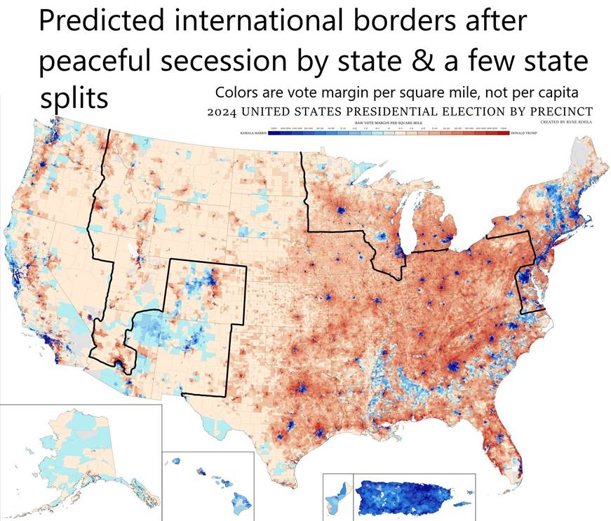
The blue-state country could be given sovereignty over US-94 from Michigan to Chicago via Indiana, as long as the Indiana on ramps and off ramps are closed Indiana can use US 80/90. Indiana could retain control over its Lake Michigan coast by keeping control of the underpasses
The East Coast can get to Michigan through Canada by roads and bridges, or through international waters/airspace over Lake Erie. Maybe Ohio and PA would give them jurisdiction over a rail line from NY to Michigan, to keep the peace.

Not everyone is as conservative as me, so they don’t value getting rid of blue parts of their state, even though it would mean conservatives could pass state legislation without moderate votes. They just want their state to look big on a map.
Fortunately, 25% of blue-state Trump voters say they’ll move in, and 50% of red-state liberals say they’ll leave the red-state federation, so even a purple state will get redder. I think only the reddest states will have the guts to make the fixes necessary after they are free of DC.
I still think that splitting Illinois and Virginia are important to keep blue state law out of the middle of our territory. If Arizona wants to join and Colorado doesn’t, then ideally AZ should split to make Colorado contiguous with the Left Coast (without the help of Mexico). Pennsylvania should split so that large numbers can be in the country they prefer.
Check out our article on where North America should split after a civil war:
https://redstatesecession.org/what-borders-should-a-red-state-federation-choose-after-a-civil-war/
Don’t miss our future articles! Subscribe to our free Substack to get them in your email inbox.
Your picture of Arizona reminded me of a map I came up with a while ago. It was based on USGS watersheds. Especially in the western US, water is a huge deal between states. My map has “flyover country” with the addition of Alberta, Saskatchewan, and parts of Manitoba within the watershed states. The Colorado river watershed in Arizona would go all the way down to the gulf as you portrayed.
CA and Cascadia are split along with most of BC from the Frasier river valley to the Pacific and the panhandle of AK. On the eastern side, I had the Chesapeake watershed. There was the Great Lakes watershed + Illinois and Rock rivers for Chicago, Milwaukee, and Madison. The northeast would join up with the rest of Canada minus the French speaking parts from the Canadian shield to the Atlantic.
I have been following your work from afar for a while. I like your detailed analysis.