On one hand, in the American system, The People of a state are the locus of ultimate sovereignty, according to the Declaration of Independence, not the people of a county, or even the people of the Union.
On the other hand, in hindsight, people would be happier if state lines had been drawn much differently.
On the first hand, state identity/pride/bias is very real, according to studies. Not as strong as nationalism, but of the same kind, depending on the state. Polling of Texas & Florida shows that people don’t want their state split.
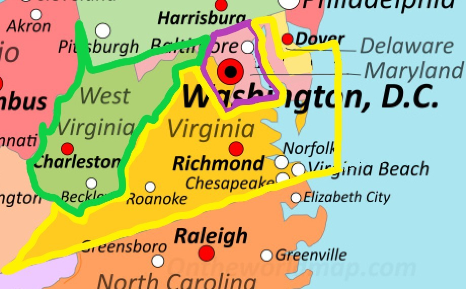
Since the US Constitution was adopted, state lines have been relocated slightly more than a couple dozen times, but only twice have they relocated populated areas. That was in 1863 when one county, and then another county of Virginia relocated to West Virginia.
On the other hand, could we have county-by-county referendums just once to redraw the lines? The US has ossified since it seceded from Great Britain 250 years years ago, and some states haven’t changed shape in 4 centuries.
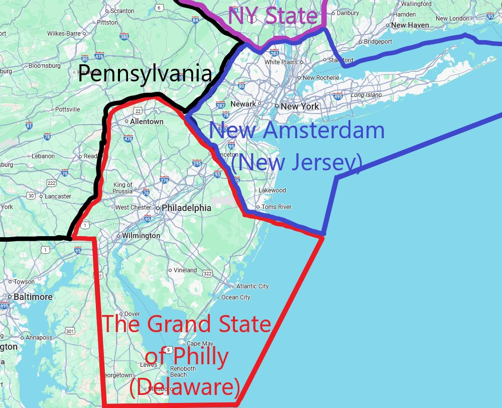
State law means more if the bulk of the population isn’t within a few minutes travel of another state’s law. A state prohibition on abortion doesn’t mean much if much of the state’s population lives one bridge away from an abortion center in another state.
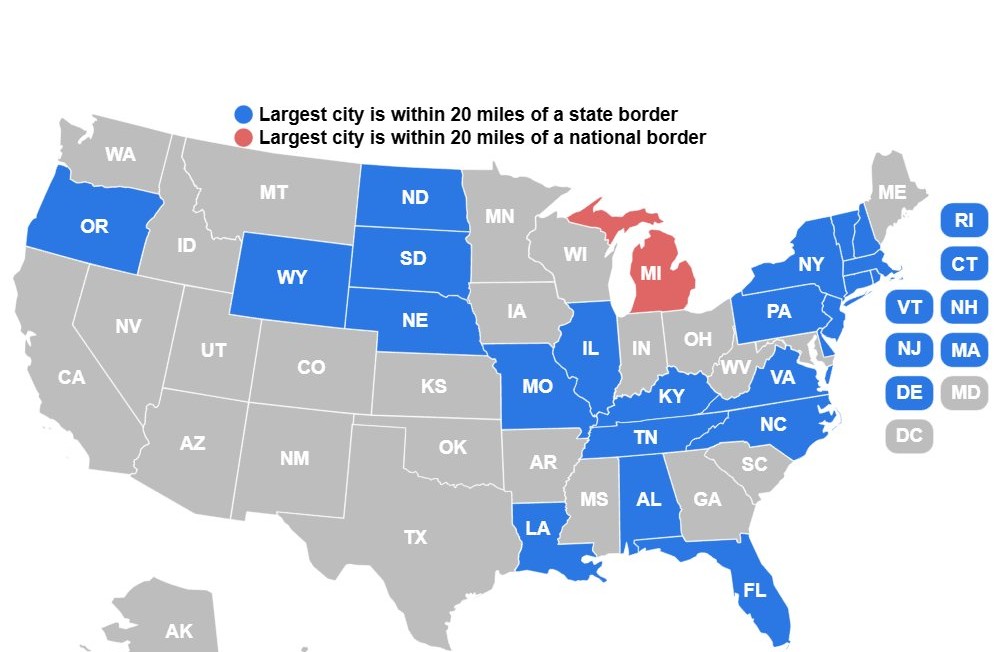
Ideally, each of our nation’s greatest metro areas would have a say in state governance at least 40 miles in every direction, minimum. But this doesn’t happen if the metro area is split into multiple states. For 26 of our 50 states, the edge of the largest metro area in the state is within 20 miles of another state or country. For another 7 states, it’s 20 to 40 miles.

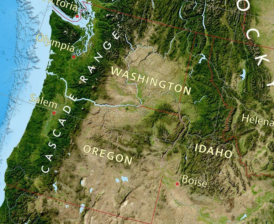
More reasons to redraw: eastern Oregon, eastern Washington & western Colorado are separated from the major resources in their states by a mountain range that’s nearly impassable at times in Winter. This wouldn’t be true if they were a part of Idaho or Utah. Political movements to relocate state lines there have many more arguments that are peculiar to their local situation.
Cultural maps, just as much as maps of election results, show that almost every state has its lines in the wrong place, if the goal is to align state policy with what the residents in a county feel comfortable with.
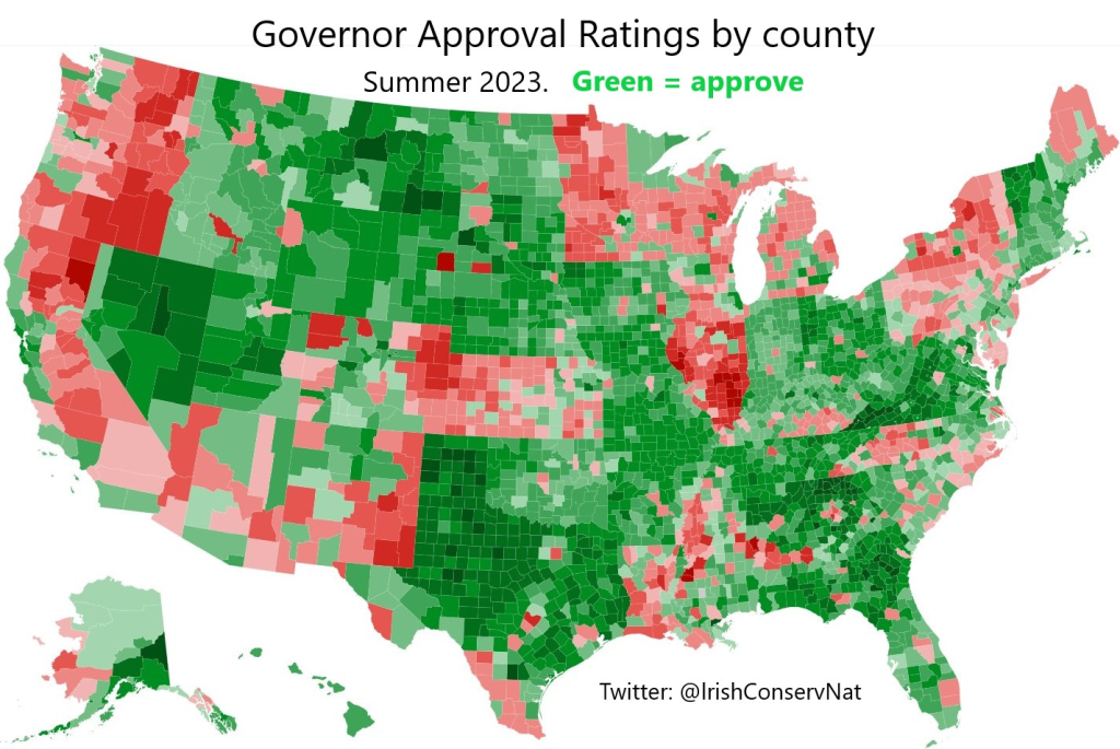
Look how unhappy (red) conservative (rural) counties are in states with a Dem governor (including Kansas, North Carolina, and Louisiana in 2023).
Trump administration official Michael Anton wrote an essay in 2021 proposing a constitutional amendment to allow any contiguous county, with Congressional approval, to switch states. I resisted the idea then because it violates state sovereignty.
But now looking at this map is the final straw for me. I feel that it’s malicious to not allow counties to re-align just this once after 4 centuries, even if it’s without the parent state’s consent. This map shows that this is not just a matter of a few states.
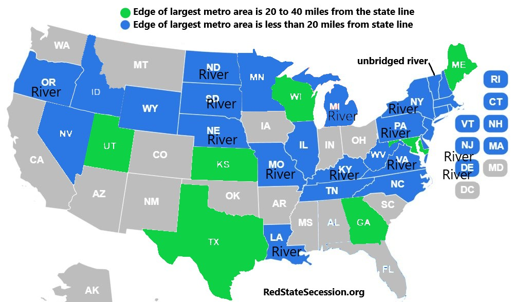
Before bridges were built in virgin territory, it made sense for rivers to be the state boundary, because they were barriers to travel. Today, river valleys are unified socio-economic units, with commuters crossing every day. Vermont’s largest metro has a population of less than 300k, so it’s still waiting for a bridge to be built across the river it’s on. But that’s not true for the other 13 states I labelled “River” on the map above. For 11 of those states, their largest metro areas are in two or more states. Probably all 26 blue states have commuters across state lines.
Before bridges, ferries were used to cross rivers, which were slow, dangerous, sometimes iced out, and couldn’t accommodate railroads or heavy traffic. In the US, improved availability of steel caused this problem to be solved by a building boom of bridges in the 1870’s and 80’s. 140 years later, state lines have not yet adjusted to the age of steel.
Additionally, before the automobile in the early 1900’s, 25 miles was considered a day’s journey by carriage, not a 25-minute commute.
When state lines were established, it was impossible to predict what kinds of people would settle where. It was difficult to predict, before the industrial revolution, which cities would grow more. Many states got their shapes from accidents of history or from pure ignorance.
Why not allow a do-over, now that we have the benefit of these new facts, to adjust to new realities? Status-quo bias is our greatest political enemy. Tradition is great, but irrational passivity is terrible. I’m not saying we have to do this every 2 centuries, or every 6 generations. Just once, because the continent wasn’t populated or industrialized or bridged when the lines were first established.
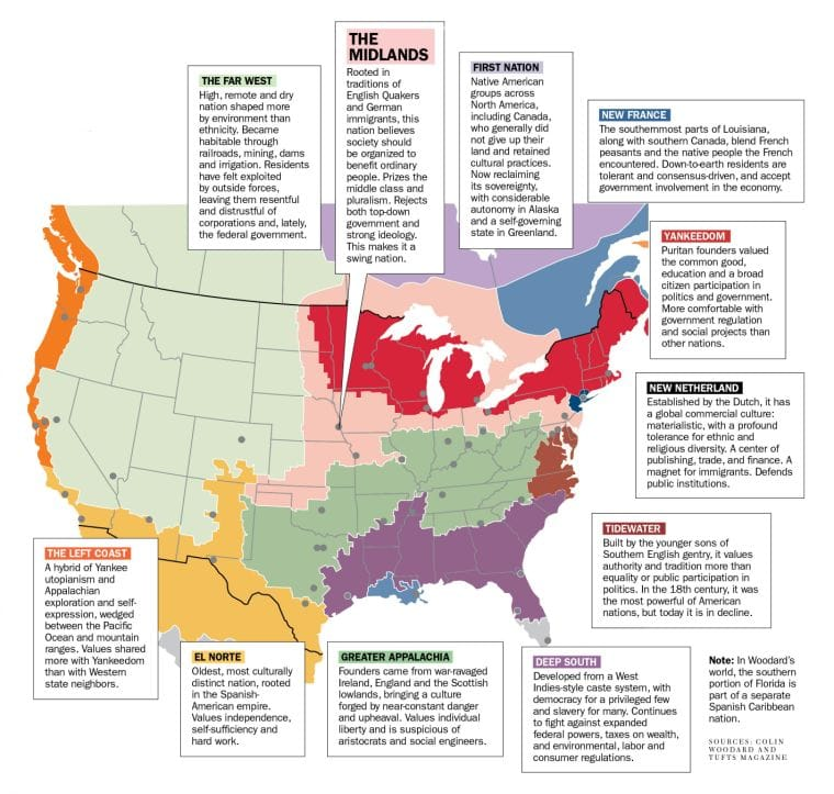
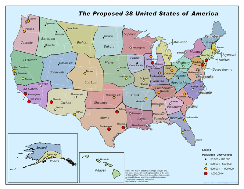
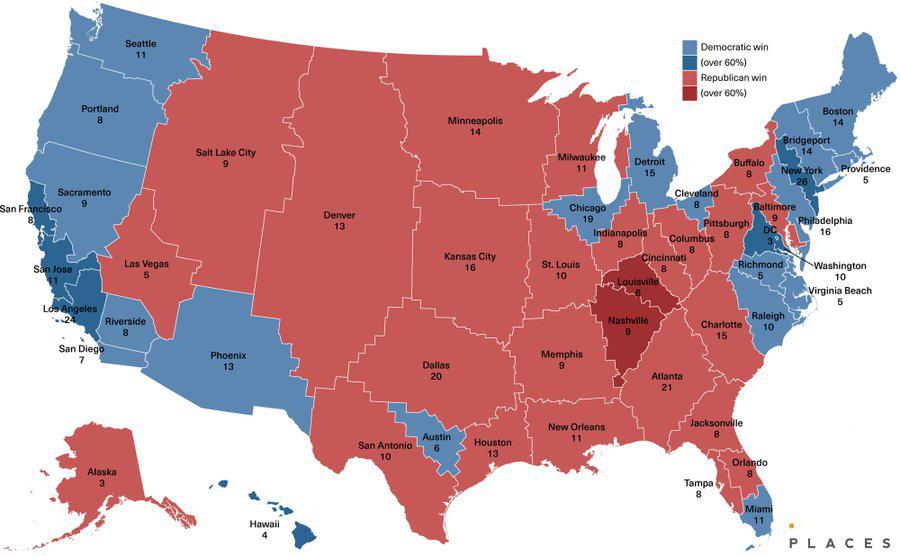
Here’s some proposals for partitioning the US in a way that puts major population centers in the centers of states.
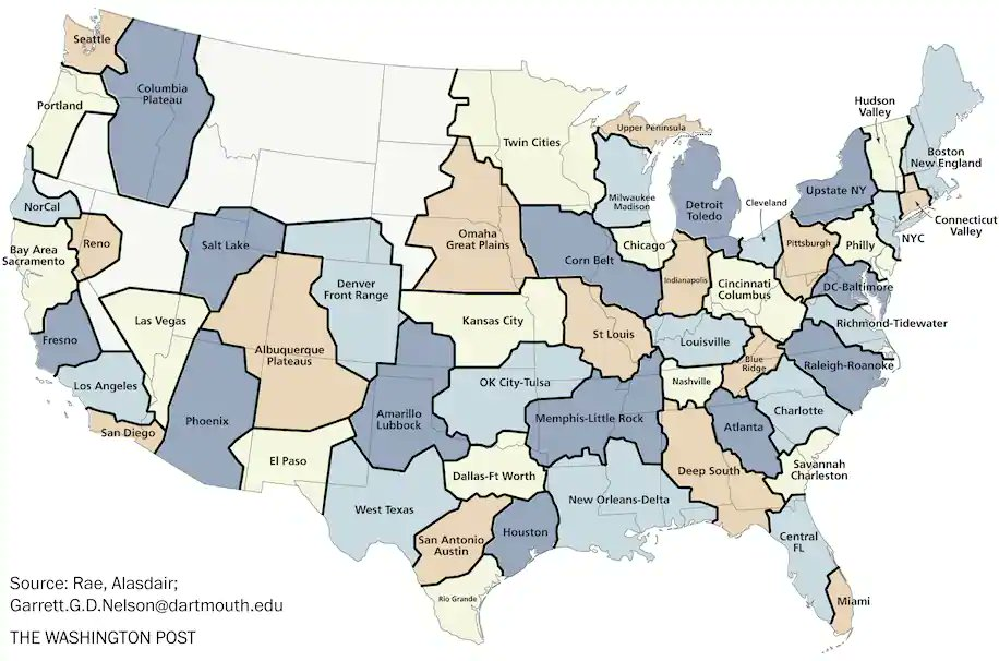
This one is interesting (although imperfect) because it shows that states are more moderate if each one has a major metro area surrounded by hinterlands. But it’s pretty even: blue gets 270 electoral votes, red 268. It’s missing the Birmingham, Alabama metro area though.
Until it’s amended, the US Constitution requires consent of the parent state to add a new state to the Union from its territory (Art 4 Section 3). And the 10th Amendment leaves authority over relocating state lines to both states involved, with approval of Congress required by Article 1 Section 10. Many activists have tried to get their state legislatures to consider ceding whole counties, but have never gotten any interest from the governing party. This is why a constitutional amendment is required.
Since ratification of an amendment takes 3/4 of states, it seems that only a National Divorce or a civil war will relocate state lines or create a new state. One might imagine that the addition of Puerto Rico or the District of Columbia to our Union might be an opportunity to add an equal number of red states, but it’s more likely that Dems will wait until they have enough power to add blue states without adding red states, since this is their main motivation for raising the issue in the first place.
Don’t miss our future articles! Subscribe to our free Substack to get them in your email inbox.
Learn how activists have tried to increase the sovereignty of counties here:
One thought on “Should we allow counties to secede from a state without its permission?”